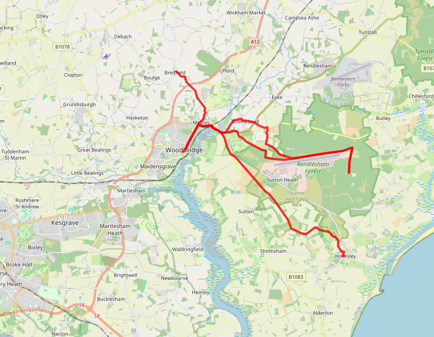
IVSH Woodbridge network NOW using cyclable public rights of way
Inter-Village Super Highway routes
Route detail based on public rights of way:
IVSH W1 - Woodbridge to Bredfield
Linked villages = Woodbridge>Melton>Bredfield
Distance = 3 mi
Path type = earth/grass/paved
Muddy when wet - 0.25 mile
IVSH W2 1 or 2 - Woodbridge>Rendlesham Forest
Linked villages = Woodbridge>Melton>Bromeswell>Rendlesham Forest
Distance = Approx 7 mi
Path type = earth/grass/paved
Muddy when wet - 0.5 mile. Sandy sections.
IVSH W4 - Woodbridge>Hollesley
Linked villages = Woodbridge>Melton>Sutton>Hollesley
Distance = 7.5 mi
Path type = SAND/earth/grass/paved
Muddy when wet - 0.5 mile

Inter-Village Super Highway routes
Route detail based on todays public rights of way:
IVSH1 - Henley to Ipswich
Linked villages = Henley-Witnesham-Westerfield>Ipswich
Distance = 5 mi
Path type = earth/grass/paved
Muddy when wet - 1 mile
IVSH2 - Martlesham to Ipswich
Linked villages = Martlesham-Kesgrave-Rushmere>Ipswich
Distance = 6.5 mi
Path type = earth/grass/paved
Muddy when wet - 0.25 mile
IVSH3 - Grundisburgh to Ipswich
Linked villages = Grundisburgh-Playford-Rushmere>Ipswich
Distance = 7 mi
Path type = earth/grass/paved
Muddy when wet - 0.5 mile
IVSH4 - Felixstowe to Ipswich
Linked villages = Felixstowe-Trimley-Levington>Nacton>Ipswich
Distance = 10 mi
Path type = earth/grass/paved
Muddy when wet - 0.5 mile
IVSH5 - Shotley to Ipswich (TBC)
Linked villages = Shotley-Chelmondiston-Woolerstone-Wherestead>Ipswich
Distance = 9 mi
Path type = earth/grass/paved
Muddy when wet - 1.5 mile
IVSH6 - Manningtree to Ipswich
Linked villages = Manningtree-Brantham-Bentley-Belstead>Ipswich
Distance = 13 mi
Path type = earth/grass/paved
Muddy when wet - 2 mile
IVSH7 - Hadleigh to Ipswich
Linked villages = Hadleigh-Radon-Chattisham-Copdock>Ipswich
Distance = 12 mi
Path type = earth/grass/paved
Muddy when wet - 2 mile